Feedback form
Illicit plants control platform
Description
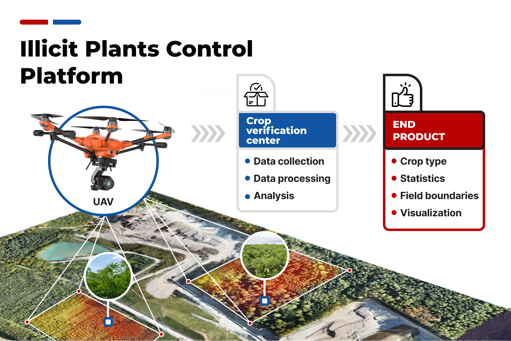
Detection of illicit cannabis plants with the help of spectral cameras mounted on drones to create maps of illegal cannabis plantation.Problem
Illegal plant cultivation remains a big problem in society. Such plants can be grown in the backyard or in the middle of a field. Existing methods for detecting such plants are far from ideal. They may be accurate, but only work in close proximity to the plant, or they may be able to work over a large area, but with extremely low accuracy.Solution
Plants emit different light spectra depending on their metabolic processes, which allows scientists to distinguish them as a separate group. The use of spectral cameras has become a popular tool in the mapping of the surface of an area under investigation. These cameras are able to capture and analyze the light emissions from plants and other objects in the area, allowing for the creation of detailed maps that reveal the distribution and types of vegetation, as well as other features of the area. However, the data obtained from these maps is often complex and difficult to interpret. To address this issue, researchers have developed neural networks that are specifically trained to process the spectral data collected by the cameras. By using these networks to analyze the data, it is possible to obtain more accurate and detailed information on the condition of the surveyed area, such as the health and growth rate of the plants, and the presence of invasive or illegal species. These techniques have proven to be invaluable for researchers and conservationists who are working to better understand and protect the natural world.Description
Detection of illicit cannabis plants with the help of spectral cameras mounted on drones to create maps of illegal cannabis plantation.Problem
Illegal plant cultivation remains a big problem in society. Such plants can be grown in the backyard or in the middle of a field. Existing methods for detecting such plants are far from ideal. They may be accurate, but only work in close proximity to the plant, or they may be able to work over a large area, but with extremely low accuracy.Solution
Plants emit different light spectra depending on their metabolic processes, which allows scientists to distinguish them as a separate group. The use of spectral cameras has become a popular tool in the mapping of the surface of an area under investigation. These cameras are able to capture and analyze the light emissions from plants and other objects in the area, allowing for the creation of detailed maps that reveal the distribution and types of vegetation, as well as other features of the area. However, the data obtained from these maps is often complex and difficult to interpret. To address this issue, researchers have developed neural networks that are specifically trained to process the spectral data collected by the cameras. By using these networks to analyze the data, it is possible to obtain more accurate and detailed information on the condition of the surveyed area, such as the health and growth rate of the plants, and the presence of invasive or illegal species. These techniques have proven to be invaluable for researchers and conservationists who are working to better understand and protect the natural world.Financial Model
Time to launch the project: 6 months
Payback: 12 months
Interested in the project?
Geography
We have experience in working with clients in more than 20 countries: we understand how local legislation, mentality and experience influence technologies and innovation approaches
Our representations: Bahrain, China, Finland, Germany, Hong Kong, India, Indonesia, Italy, Kazakhstan, Malaysia, Singapore, South Korea, Switzerland, Thailand, Turkey, UAE, USA, Uzbekistan, Vietnam


